Saturday, November 25, 2006

Knights Valley Escapade

The sun was shining as Len and I left from San Miguel School for a jaunt towards Calistoga. The crisp air and picturesque yellow vineyards made the ride up Chalk Hill almost effortless. At Alexander Valley Road we headed east for a beautiful six mile stretch of Highway 128. Hordes of friendly cyclists waved as we raced through the Knights Valley. We arrived at Ida Clayton Road for some post-Thanksgiving calorie burning. This quiet, winding road climbs over 1,800 feet in the first four miles, making it a tough “three-chevron” grade. As we ascended, the views became increasingly more spectacular (see photo). The sounds of wildlife surrounded us and white waterfalls lined the roadside. Our arm and leg warmers served us well as there were only brief spots of sunshine during the final four chilly miles. Enormous potholes covered the roughly paved road as we approached the top. We crossed over into Lake County (Western Mine Road) for a “nature” break and re-hydration (see photo). With our water supplies now depleted, we zoomed carefully down the 8 miles of Ida Clayton Road and traveled back onto the 128 corridor towards Healdsburg. We made our way up the reverse side of Chalk Hill Road back to Faught. Our efforts were rewarded with gourmet sandwiches and deep fried potato wedges at the Molsberry Market in Larkfield. Our ride covered 51.4 miles while climbing over 3,500 feet. Another fun and fulfilling afternoon in paradise. Wahoo!

Saturday, November 18, 2006

Climbin’, Cruisin’, and Crashin’

Debbie, Twyla, Len, Jim (GarMan), and I met at the Cotati Vets Hall to rendezvous with the Santa Rosa Cycling Club for a new hilly climbing route out to the coast. Our brightly colored peloton of 25 cyclists departed amidst foggy skies and moderate temperatures. Most cars yielded the right of way to our big cycling group as we navigated through city traffic. We made our way to the climb up Liberty Road via Stony Point, Jewett, and Center. Our group dispersed as we approached Skillman Lane for a moderate ascent up Eucalyptus Avenue. This route included some very challenging rolling hills over poorly paved county roads. About half way over Middle Two Rock, the climb turned into a screaming descent at Purvine Road. Jim Finn, our GPS navigator, took a nasty spill speeding around the turn and crashing his bike. Debbie and Twyla graciously waited while Jim was transported to Petaluma Valley Hospital, where he was diagnosed and treated for a broken collarbone (click on x-ray photo for details). 
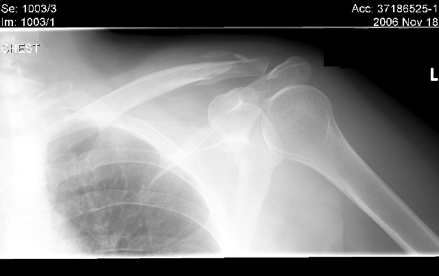
Jim’s spirits remained positive throughout the ordeal and we look forward to him rejoining the peloton soon. The ride continued up Spring Hill Road until Valley Ford. This seven mile stretch towards the coast had wide shoulders and we enjoyed the flat change of terrain. Next we were treated to a series of steady climbs up Gericke, Fallon-Two Rock, Whitaker Bluff, and Middle Road. Hundreds of sheep packed into Marin County farms lined our route. The midday sun heated up and we shed our arm/leg warmers before descending rapidly into Tomales via Dillon Beach. The bakery was swamped as cyclists, motorcycling clubs, and locals enjoyed fresh pastries (see photo). After devouring cinnamon rolls and nut bars (they were sold out of sticky buns), we headed north, climbing onto Highway 1, descending down Fallon-Two Rock, and climbing back onto Carmody. This route was like a nonstop rollercoaster ride. The cows were out in droves with baby calves all around. We made our way towards Valley Ford onto Walker Road, a very bumpy ascent ending at Pepper. To get back to Cotati, we cycled another five miles onto Mecham, Stony Point, and West Sierra. It was a gorgeous day to cycle 48 miles with friends. Best wishes from all of us, Jim, for a speedy recovery!

Wednesday, November 15, 2006

The Great Weekday Escape!

Jim Finn, a critical care physician & anesthesiologist, met me at Aroma Roasters for a Wednesday cycling trek out to Marin County. Jim proudly demonstrated his handlebar mounted Garmin eTrex Vista Cx GPS along with a sophisticated heart rate monitor/fitness computer. Taking advantage of this beautiful crisp fall day, we began our ride westward on the Joe Rodota Trail towards Sebastopol. We navigated through the weekday traffic downtown, past Analy High School and onto Occidental, Mill Station, and Sullivan Roads. We began the steep climb up Graton Road. Jim was a trouper working his double crank-set up the hill. We rested briefly at Tenuda to catch our breath and re-hydrate before rapidly descending into Occidental. After a refreshment stop at the Union Hotel, we zoomed down the shaded cold Bohemian Highway descent towards Freestone. We passed the closed Wildflour Bakery (how sad) and continued onto Bodega Highway toward Valley Ford. After passing through this quaint town, we crossed into Marin County, admiring the beautiful landscapes, rolling hills, blue skies, and an abundance of sheep (there were hundreds). We continued the journey proceeding to ascend Franklin School, Whittaker Bluff, and the Highway 1 hills. Throughout the ride Jim would reference his Garmin handlebar mounted electronics announcing the current climbing grades, calories burned, geographic location, heart-rate, and elevations. It was like riding with a personal cycling Sherpa. So, I think we’ll dub him “GarMan” (after all his Garmin brand onboard toys). We rode past the Marin County line (see photo) in the direction of Bloomfield. Making our way towards Sebastopol, we navigated traffic on the nagging grades of Bloomfield and Pleasant Hill Roads ending with a killer descent down Highway 116. We cycled onto Main Street before traveling east on the Joe Rodota trail. The weather was absolutely perfect. Upon our arrival in Santa Rosa’s Railroad Square, we stopped at the Flying Goat outdoor café for some delicious high-protein muffins, people watching, and great conversation. We had a fulfilling day cycling 56 miles while enjoying beautiful Northern California. Wahoo!